
作物杂志,2020, 第3期: 177–183 doi: 10.16035/j.issn.1001-7283.2020.03.027
利用无人机遥感技术提取农作物植被覆盖度方法研究
王猛1,2, 隋学艳1,2, 梁守真1,2, 侯学会1,2, 梁永全3
- 1山东省农业可持续发展研究所,250100,山东济南
2农业农村部华东都市农业重点实验室,250100,山东济南
3山东省智慧矿山信息技术重点实验室,266590,山东青岛
Research on the Method of Extracting Crop Vegetation Coverage Using UAV Remote Sensing Technology
Wang Meng1,2, Sui Xueyan1,2, Liang Shouzhen1,2, Hou Xuehui1,2, Liang Yongquan3
- 1Shandong Institute of Agriculture Sustainable Development, Jinan 250100, Shandong, China
2Key Laboratory of East China Urban Agriculture, Ministry of Agriculture and Rural Affairs, Jinan 250100, Shandong, China
3Shandong Key Laboratory of Wisdom Mine Information Technology, Qingdao 266590, Shandong, China
摘要:
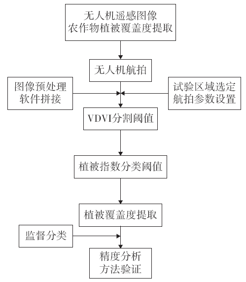
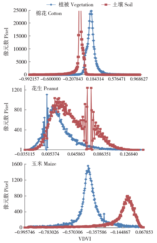
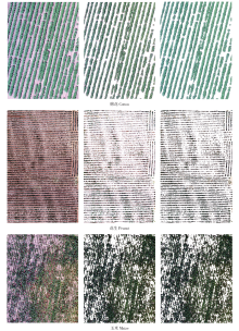
基于无人机的遥感信息获取技术已广泛应用在农业领域。无人机遥感平台获取农作物信息技术具有高时效、高分辨率、低成本、快速、准确等特点,是目前精准农业中农田信息获取的重要手段之一。利用无人机遥感技术获取可见光影像,以棉花、花生和玉米为研究对象,选取不同的植被指数进行可见光图像阈值分割,结合研究区域可见光影像监督分类结果,确定3种作物提取植被覆盖度方法。试验结果表明,利用无人机可见光图像植被指数阈值分类方法,可以有效提取作物植被覆盖度。该方法对于棉花、花生和玉米3种作物植被覆盖信息的提取精度较高。


| [1] | 陈仲新, 任建强, 唐华俊 , 等. 农业遥感研究应用进展与展望. 遥感学报, 2016,20(5):748-767. |
| [2] | 宋清洁, 崔霞, 张瑶瑶 , 等. 基于小型无人机与MODIS数据的草地植被覆盖度研究——以甘南州为例. 草业科学, 2017,34(1):40-50. |
| [3] | 戴建国, 张国顺, 郭鹏 , 等. 基于无人机遥感可见光影像的北疆主要农作物分类方法. 农业工程学报, 2018,34(18):122-129. |
| [4] | 郭鹏, 武法东, 戴建国 , 等. 基于无人机可见光影像的农田作物分类方法比较. 农业工程学报, 2017,33(13):112-119. |
| [5] | 高林, 杨贵军, 李红军 , 等. 基于无人机数码影像的冬小麦叶面积指数探测研究. 中国生态农业学报, 2016,24(9):1254-1264. |
| [6] | 丁雷龙, 李强子, 杜鑫 , 等. 基于无人机图像颜色指数的植被识别. 国土资源遥感, 2016,78(1):78-86. |
| [7] |
Bendig J, Yu K, Aasen H , et al. Combining UAV- based plant height from crop surface models,visible,and near infrared vegetation indices for biomass monitoring in barley. International Journal of Applied Earth Observation and Geoinformation, 2015,39:79-87.
doi: 10.1016/j.jag.2015.02.012 |
| [8] | Kyratzis A C, Skarlatos D P, Menexes G C , et al. Assessment of vegetation indices derived by UAV imagery for durum wheat phenotyping under a water limited and heat stressed mediterranean environment. Frontiers in Plant Science, 2017,8:1-14. |
| [9] |
Wei L X, Yang B, Jiang J P , et al. Vegetation filtering algorithm for UAV- borne lidar point clouds:acase study in the middle- lower Yangtze River riparian zone. International Journal of Remote Sensing, 2017,38(8/9/10):2991-3002.
doi: 10.1080/01431161.2016.1252476 |
| [10] | 汪小钦, 王苗苗, 王绍强 , 等. 基于可见光波段无人机遥感的植被信息提取. 农业工程学报, 2015,31(5):152-159. |
| [11] | 赵健赟 . 地表植被覆盖度遥感估算及其气候效应研究进展. 测绘与空间地理信息, 2015,38(8):77-80. |
| [12] |
Song W J, Mu X H, Ruan G Y , et al. Estimating fractional vegetation cover and the vegetation index of bare soil and highly dense vegetation with a physically based method. International Journal of Applied Earth Observation and Geoinformation, 2017,58:168-176.
doi: 10.1016/j.jag.2017.01.015 |
| [13] | 牛亚晓, 张立元, 韩文霆 , 等. 基于无人机遥感与植被指数的冬小麦覆盖度提取方法. 农业机械学报, 2018,49(4):212-221. |
| [14] |
Jia K, Liang S L, Gu X F , et al. Fractional vegetation cover estimation algorithm for Chinese GF-1 wide fieldview data. Remote Sensing of Environment, 2016,177(5):184-191.
doi: 10.1016/j.rse.2016.02.019 |
| [15] | Choi S, Heuk J S, Yeon C D . Estimation of fractional vegetation cover in sand dunes using multi-spectral images from fixedwing UAV. Journal of the Korean Society of Survey,Geodesy,Photogrammetry, and Cartography, 2016,34(4):431-441. |
| [16] | 李冰, 刘镕源, 刘素红 , 等. 基于低空无人机遥感的冬小麦覆盖度变化监测. 农业工程学报, 2012,28(13):160-165. |
| [17] | 赵静, 杨焕波, 兰玉彬 , 等. 基于无人机可见光图像的夏季玉米植被覆盖度提取方法. 农业机械学报, 2019,50(5):232-240. |
| [18] | 童威 . 基于ENVI的遥感影像监督分类方法的研究. 科技创新与应用, 2019,36(23):6-9. |
| [19] |
Gamon J A, Surfus J S . Assessing leaf pigment content and activity with a reflectometer. New Phytologist, 1999,143(1):105-117.
doi: 10.1046/j.1469-8137.1999.00424.x |
| [20] |
Sellaro R, Crepy M, Trupkin S A , et al. Cryptochrome as a sensor of the blue/green ratio of natural radiation in Arabidopsis. Plant Physiology, 2010,154(1):401-409.
doi: 10.1104/pp.110.160820 |
| [21] |
Claverie M, Demarez V, Duchemin B , et al. Maize and sunflower biomass estimation in southwest France using high spatial and temporal resolution remote sensing data. Remote Sensing of Environment, 2012,124:844-857.
doi: 10.1016/j.rse.2012.04.005 |
| [22] |
Peng D L, Huete A R, Huang J F , et al. Detection and estimation of mixed paddy rice cropping patterns with MODIS data. International Journal of Applied Earth Observation and Geoinformation, 2011,13(1):13-23.
doi: 10.1016/j.jag.2010.06.001 |
| [1] | 陈迪文,周文灵,敖俊华,黄莹,江永,韩西红,秦益民,沈宏. 海藻提取物对甜玉米产量、品质及氮素利用的影响[J]. 作物杂志, 2020, (2): 134–139 |
| [2] | 李迪秦,卢政言,王艳,钟仪,刘铭辉,王青,江祥伟,陆超,丁春霞. 栀子和玉兰花提取物对烤烟主要化学成分及致香物质含量影响[J]. 作物杂志, 2020, (1): 136–140 |
| [3] | 崔勇,马自清,田恩平. 20年来宁夏中南部山区农业生产发展分析[J]. 作物杂志, 2019, (2): 28–38 |
| [4] | 黄文辉, 王会, 梅德圣. 农作物抗倒性研究进展[J]. 作物杂志, 2018, (4): 13–19 |
| [5] | 吴建富,卢志红,胡丹丹. 科学认识有机肥料在农业生产中的作用[J]. 作物杂志, 2017, (5): 1–6 |
| [6] | 王连喜,刘畅,李琪,吴东丽,王清,成威. 气候变暖背景下京津冀地区冬小麦种植北界变化[J]. 作物杂志, 2017, (1): 61–67 |
| [7] | 石景雨,何丽莲,王先宏,李富生. 不同甘蔗品种叶片中总黄酮含量与提取工艺的优化研究[J]. 作物杂志, 2016, (5): 19–24 |
| [8] | 刘建光,王永强,赵贵元,赵俊丽,张寒霜. 重离子辐照诱变育种应用及其生物学效应研究进展[J]. 作物杂志, 2016, (3): 12–16 |
| [9] | 李琪,孙晓宇,王连喜,缪淼,吴东丽. 基于不同植被指数的VSWI在河南省春季干旱监测中的应用分析[J]. 作物杂志, 2016, (1): 162–168 |
| [10] | 李海燕, 段玉玺, 陈立杰. 大豆植株中类黄酮对大豆胞囊线虫的毒杀效果及机理研究[J]. 作物杂志, 2015, (1): 57–60 |
| [11] | 周晶, 曾庆涛, 刘铨义, 等. 一种适用于棉花种子的DNA快速提取方法[J]. 作物杂志, 2014, (2): 31–33 |
| [12] | 申晓慧, 张华, 冯鹏, 等. 延胡索氯仿提取物对12种病原真菌的离体抑菌活性筛选[J]. 作物杂志, 2013, (6): 56–59 |
| [13] | 邢美莲, 贾鹏燕, 冯冬艳, 等. 吴茱萸不同溶剂提取物抗氧化和抑菌性研究[J]. 作物杂志, 2013, (6): 76–78 |
| [14] | 刘录祥, 赵林姝, 郭会君, 等. 高产、抗逆小麦新品种航麦901简介[J]. 作物杂志, 2013, (5): 157–157 |
| [15] | 高圆圆, 张玉涛, 张宁, 等. 小型无人机低空喷洒在小麦田的雾滴沉积分布及对小麦吸浆虫的防治效果初探[J]. 作物杂志, 2013, (2): 139–142 |
|
||