
作物杂志,2021, 第2期: 183–190 doi: 10.16035/j.issn.1001-7283.2021.02.027
所属专题: 玉米专题
结合植被指数与纹理特征的玉米冠层FAPAR遥感估算研究
王思宇1,2( ), 聂臣巍2, 余汛2,3, 邵明超2,4, 王梓旭2,5, 努热曼古丽·托乎提2,6, 刘亚东2, 程明瀚2,7, 官云兰1(), 金秀良2()
- 1东华理工大学测绘工程学院,330013,江西南昌
2中国农业科学院作物科学研究所,100081,北京
3河南理工大学,454003,河南焦作
4河北工程大学地球科学与工程学院,056006,河北邯郸
5长安大学地球科学与资源学院,710061,陕西西安
6中国地质大学(武汉)地球科学学院,430074,湖北武汉
7河海大学农业工程学院,210098,江苏南京
Maize Canopy FAPAR Remote Sensing Estimation Combining Vegetation Indexes and Texture Characteristics
Wang Siyu1,2(), Nie Chenwei2, Yu Xun2,3, Shao Mingchao2,4, Wang Zixu2,5, Nuremanguli· Tuohuti2,6, Liu Yadong2, Cheng Minghan2,7, Guan Yunlan1(), Jin Xiuliang2()
- 1Faculty of Geomatics, East China University of Technology, Nanchang 330013, Jiangxi, China
2Institute of Crop Sciences, Chinese Academy of Agricultural Sciences, Beijing 100081, China
3Henan Polytechnic University, Jiaozuo 454003, Henan, China
4School of Earth Science and Engineering, Hebei University of Engineering, Handan 056006, Hebei, China
5School of Earth Sciences and Resources, Chang'an University, Xi’an 710061, Shaanxi, China
6School of Earth Sciences, China University of Geosciences, Wuhan 430074, Hubei, China
7College of Agricultural Engineering, Hohai University, Nanjing 210098, Jiangsu, China
摘要:
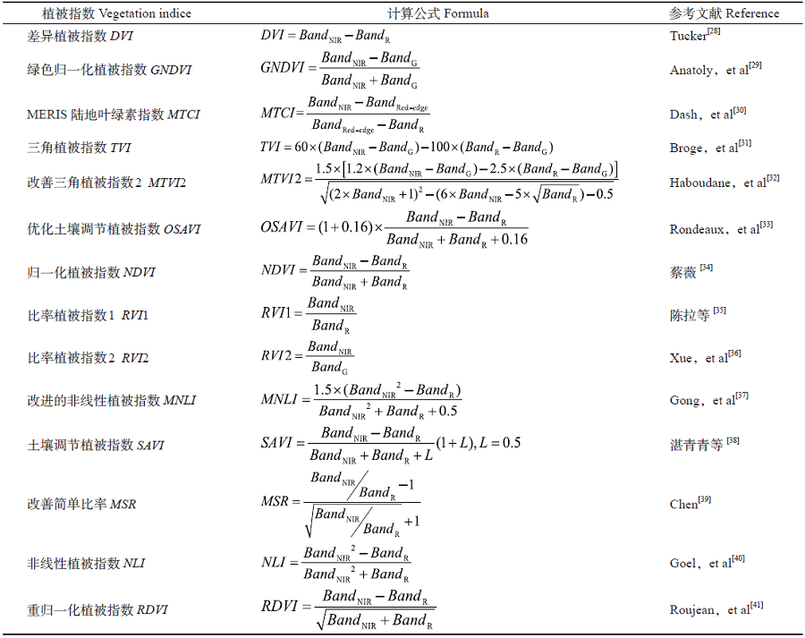
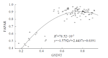
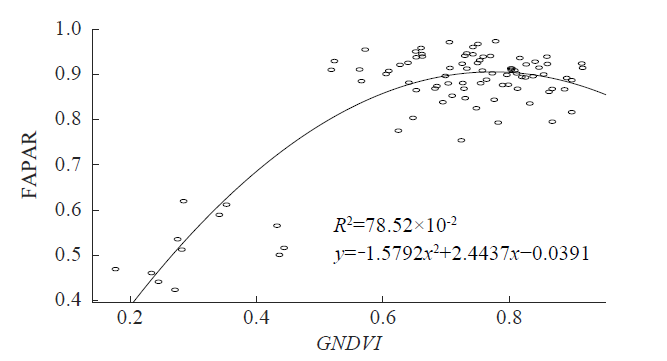
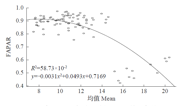
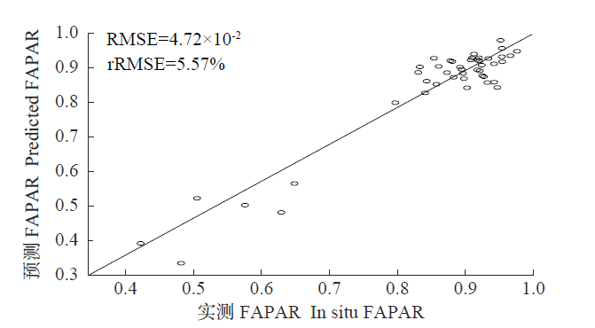
光合有效辐射吸收比率(fraction of absorbed photosynthetically active radiation,FAPAR)是反映作物产量的重要参数之一。无人机遥感能够快速无损地获取高分辨率植被冠层光谱信息,已成为进行物理化参数反演的重要手段。以不同播期玉米为研究对象,基于无人机搭载多光谱传感器,提取植被指数与植被纹理特征,使用偏最小二乘(partial least squares regression,PLSR)方法将二者结合反演玉米FAPAR,并与传统单独使用植被指数或植被纹理特征反演植被FAPAR的方法进行比较。结果表明:使用传统方法单独利用植被指数反演FAPAR(验证RMSE最低为7.33×10⁻²,rRMSE最低为8.66%)的效果比单独利用纹理特征反演FAPAR(验证RMSE最低为9.50×10⁻²,rRMSE最低为11.23%)的精度更高;使用PLSR方法单独利用植被指数或纹理特征估算FAPAR的效果比传统方法精度更高(植被指数与纹理特征的验证RMSE最低分别为6.77×10⁻²和5.24×10⁻²,rRMSE最低分别为8.01%和6.19%);使用PLSR方法将植被指数与纹理特征相结合估算FAPAR(验证RMSE最低为4.72×10⁻²,rRMSE最低为5.57%)的效果比单独使用植被指数或纹理特征估算FAPAR的精度更高。综上,使用PLSR方法将植被指数和植被纹理特征相结合来反演玉米冠层FAPAR可行,为作物FAPAR遥感反演研究提供了新的思路。

| [1] | 董泰锋, 蒙继华, 吴炳方. 基于遥感的光合有效辐射吸收比率(FAPAR)估算方法综述. 生态学报, 2012,32(22):7190-7201. |
| [2] | 周元刚. 不同受旱条件下冬小麦和夏玉米冠层光截获特征研究. 杨凌:西北农林科技大学, 2016. |
| [3] | 李贺丽, 罗毅, 薛晓萍, 等. 冬小麦冠层对入射光合有效辐射吸收比例的估算方法评价. 农业工程学报, 2011,27(4):201-206. |
| [4] | Moriondo M, Maselli F, Bindi M. A simple model of regional wheat yield based on NDVI data. European Journal of Agronomy, 2007,26(3):266-274. |
| [5] | 张宇. 基于光学和雷达遥感的水稻FAPAR协同反演. 成都:电子科技大学, 2019. |
| [6] | Zhang Y, Li S, He Z, et al. Synergistic Inversion of Rice FPAR Based on Optical and Radar Remote Sensing Data. IGARSS 2019-2019 IEEE International Geoscience and Remote Sensing Symposium. IEEE, 2019. |
| [7] | 王方永, 韩焕勇, 陈兵, 等. 数字图像估测棉花光合有效辐射吸收比例. 西北农业学报, 2015,24(10):74-79. |
| [8] | Majasalmi T, Stenberg P, Rautiainen M. Comparison of ground and satellite-based methods for estimating stand-level fPAR in a boreal forest. Agricultural and Forest Meteorology, 2017,232:422-432. |
| [9] | Liang S, Hou X, Sui X, et al. Deciduous broadleaf forests green FPAR and its relationship with spectral vegetation indices. 2017 10th International Congress on Image and Signal Processing,BioMedical Engineering and Informatics (CISP-BMEI). IEEE, 2017. |
| [10] | Tan C W, Wang D L, Zhou J, et al. Remotely assessing fraction of photosynthetically active radiation (FAPAR) for wheat canopies based on hyperspectral vegetation indexes. Frontiers in Plant Science, 2018,9:776. |
| [11] | Dong T, Meng J, Shang J, et al. Evaluation of chlorophyll-related vegetation indices using simulated sentinel-2 data for estimation of crop fraction of absorbed photosynthetically active radiation. IEEE Journal of Selected Topics in Applied Earth Observations and Remote Sensing, 2015,8(8):4049-4059. |
| [12] | 刘桂鹏, 贺婷, 王国骄, 等. 玉米LAI和FAPAR的高光谱遥感预测模型研究. 玉米科学, 2016,24(2):115-119,128. |
| [13] | 田春燕, 黄春燕, 郭晓飞, 等. 基于植被指数的棉花冠层光合有效辐射截获量和叶片净光合速率估算研究. 新疆农业科学, 2017,54(6):981-987. |
| [14] | Qin H M, Wang C, Zhao K G, et al. Estimation of the fraction of absorbed photosynthetically active radiation (FAPAR) in maize canopies using LiDAR data and hyperspectral imagery. PLoS ONE, 2018,13(5):e0197510. |
| [15] | Zhao L, Liu Z G, Xu S, et al. Retrieving the diurnal FAPAR of a maize canopy from the jointing stage to the tasseling stage with vegetation indices under different water stresses and light conditions. Sensors, 2018,18(11):3965. |
| [16] | 万亮, 岑海燕, 朱姜蓬, 等. 基于纹理特征与植被指数融合的水稻含水量无人机遥感监测. 智慧农业(中英文), 2020,2(1):58-67. |
| [17] | 张华, 张玉红, 张改改. 民勤绿洲青土湖植被优势种地上生物量估算. 干旱区地理, 2020,43(1):201-210. |
| [18] | 陈鹏, 冯海宽, 李长春, 等. 无人机影像光谱和纹理融合信息估算马铃薯叶片叶绿素含量. 农业工程学报, 2019,35(11):63-74. |
| [19] | 高凯旋, 焦海明, 王新闯. 融合影像纹理、光谱与地形特征的森林冠顶高反演模型. 国土资源遥感, 2020,32(3):63-70. |
| [20] | 谢士琴, 赵天忠, 王威, 等. 结合影像纹理、光谱与地形特征的森林结构参数反演. 农业机械学报, 2017,48(4):125-134. |
| [21] | 蔡文婷, 赵书河, 王亚梅, 等. 结合Sentinel-2光谱与纹理信息的冬小麦作物茬覆盖度估算. 遥感学报, 2020,24(9):1108-1119. |
| [22] | 贾丹, 陈鹏飞. 低空无人机影像分辨率对冬小麦氮浓度反演的影响. 农业机械学报, 2020,51(7):164-169. |
| [23] | 蒙诗栎, 庞勇, 张钟军, 等. WorldView-2纹理的森林地上生物量反演. 遥感学报, 2017,21(5):812-824. |
| [24] | 杨俊, 丁峰, 陈晨, 等. 小麦生物量及产量与无人机图像特征参数的相关性. 农业工程学报, 2019,35(23):104-110. |
| [25] | Wulder M A, LeDrew. Aerial image texture information in the estimation of northern deciduous and mixed wood forest leaf area index (LAI). Remote Sensing of Environment, 1998,64(1):64-76. |
| [26] | Cen H, Wan L, Zhu J, et al. Dynamic monitoring of biomass of rice under different nitrogen treatments using a lightweight UAV with dual image-frame snapshot cameras. Plant Methods, 2019,15(1):32. |
| [27] | Wan L, Li Y, Cen H, et al. Combining UAV-based vegetation indices and image classification to estimate flower number in oilseed rape. Remote Sensing, 2018,10(9):1484. |
| [28] | Tucker C J. Red and photographic infrared linear combinations for monitoring vegetation. Remote Sensing of Environment, 1979,8(2):127-150. |
| [29] | Anatoly A G, Merzlyak M N. Remote sensing of chlorophyll concentration in higher plant leaves. Advances in Space Research, 1998,22(5):689-692. |
| [30] | Dash J, Curran P J. The MERIS terrestrial chlorophyll index. International Journal of Remote Sensing, 2004,25(23):5403-5413. |
| [31] | Broge N H, Leblanc E. Comparing prediction power and stability of broadband and hyperspectral vegetation indices for estimation of green leaf area index and canopy chlorophyll density. Remote Sensing of Environment, 2001,76(2):156-172. |
| [32] | Haboudane D, Miller J R, Pattey E, et al. Hyperspectral vegetation indices and novel algorithms for predicting green LAI of crop canopies: modeling and validation in the context of precision agriculture. Remote Sensing of Environment, 2004,90(3):337-352. |
| [33] | Rondeaux G, Steven M, Baret F. Optimization of soil-adjusted vegetation indices. Remote Sensing of Environment, 1996,55(2):95-107. |
| [34] | 蔡薇. 基于NDVI时间序列的荷泽市东明县植被动态变化研究. 经济研究导刊, 2009(18):136-137. |
| [35] | 陈拉, 黄敬峰, 王秀珍. 不同传感器的模拟植被指数对水稻叶面积指数的估测精度和敏感性分析. 遥感学报, 2008(1):143-151. |
| [36] | Xue L, Cao W, Luo W, et al. Monitoring leaf nitrogen status in rice with canopy spectral reflectance. Agronomy Journal, 2004,96(1):135-142. |
| [37] | Gong P, Pu R, Biging G S, et al. Estimation of forest leaf area index using vegetation indices derived from hyperion hyperspectral data. IEEE Transactions on Geoscience and Remote Sensing, 2003,41(6):1355-1362. |
| [38] | 湛青青, 王辉源. 基于综合指数分析的城市建筑用地信息提取研究. 测绘与空间地理信息, 2014,37(2):62-65,69. |
| [39] | Chen J M. Evaluation of vegetation indices and a modified simple ratio for boreal applications. Canadian Journal of Remote Sensing, 1996,22(3):229-242. |
| [40] | Goel N S, Qin W H. Influences of canopy architecture on relationships between various vegetation indices and LAI and FPAR: A computer simulation. Remote Sensing Reviews, 1994,10(4):309-347. |
| [41] | Roujean J L, Breon F M. Estimating PAR absorbed by vegetation from bidirectional reflectance measurements. Remote Sensing of Environment, 1995,51(3):375-384. |
| [42] | Sun Q, Sun L, Shu M, et al. Monitoring maize lodging grades via unmanned aerial vehicle multispectral image. Plant Phenomics, 2019(2):1-16. |
| [43] | 刘思涵. 基于高分辨率影像纹理特征的落叶松人工林提取研究. 西安:西安科技大学, 2020. |
| [44] | 刘畅, 杨贵军, 李振海, 等. 融合无人机光谱信息与纹理信息的冬小麦生物量估测. 中国农业科学, 2018,51(16):3060-3073. |
| [1] | 王猛, 隋学艳, 梁守真, 侯学会, 梁永全. 利用无人机遥感技术提取农作物植被覆盖度方法研究[J]. 作物杂志, 2020, (3): 177–183 |
| [2] | 王连喜,刘畅,李琪,吴东丽,王清,成威. 气候变暖背景下京津冀地区冬小麦种植北界变化[J]. 作物杂志, 2017, (1): 61–67 |
| [3] | 李琪,孙晓宇,王连喜,缪淼,吴东丽. 基于不同植被指数的VSWI在河南省春季干旱监测中的应用分析[J]. 作物杂志, 2016, (1): 162–168 |
|
||